


In areas marked by gender inequality, women and girls are particularly at risk of the compounding effects of armed conflict and climate change. Militaries should track these risks to ensure they develop a fuller picture of the human security situation in their areas of operations. To do this effectively, militaries require a different sort of staff tool than is currently produced using ordinary operational analysis methodologies.
In this post, part of our ongoing series on Gender and Conflict co-hosted by the ICRC and Just Security, a team of recent graduates from the University of Vermont’s Rubenstein School of Environment and Natural Resources and their faculty partners propose a GIS mapping model with overlays showing the cumulative intensity of gender inequality, armed conflict, and climate change in the mission area, letting reliable data speak for itself through color.
The international community and the research literature increasingly recognize that the combination of armed conflict and climate change in situations of underlying gender inequality poses special risks for women and girls. Recent studies from UN Women and the UN Environment Programme, and from IUCN and USAID, among others, document these risks.
Research efforts are also generating important anecdotal evidence from women living in areas marked by the simultaneous occurrence of these forces as to how the impacts they suffer are different and often more severe than those experienced by the men and boys in their families and communities. Militaries need to be able to assess these gender-differentiated impacts to form a more complete picture of the human security situation in their mission areas. Only then will they be able to act deliberately and consistently in ways that would better promote the security of all people living in these areas.
The problem
Researchers such as Fröhlich and Gioli, however, have noted the difficulty in factoring these complex relationships into a workable theory that would assist in the analysis of situations in the field. There is a broad range of social, political and economic factors that mediate the different effects of armed conflict and climate change on women and girls. For example, in some regions during times of food scarcity, families will prioritize feeding their sons rather than their daughters. Even within these communities, however, girls from wealthier families might avoid this discriminatory distribution of food while their peers from poorer families might suffer significantly. In areas in which both armed conflict and climate change are occurring, it could be very difficult to accurately determine the different impacts of each, or whether these impacts are actually influencing each other.
Translating this complexity into methodologies and actionable intelligence to support lines of effort in military missions poses perhaps even greater challenges. Simply put, this intersection does not lend itself to easy analysis using ordinary military planning processes or even gender analyses adapted to military contexts. For example, as set out in U.S. joint planning doctrine, the PMESII style of operational analysis (Political, Military, Economic, Social, Information and Infrastructure), is widely used in militaries today. Although it appears holistic on its face, this form of analysis tends to be linear, breaking down information about relationships into different siloes rather than exploring new interactions between cross-cutting and non-traditional operational factors such as gender and climate change.
As for typical operational gender analysis products, they are often set out in textual forms or in matrices. These formats do not easily support the reasoned and deliberate allocation of scarce resources to address factors such as gender inequality and climate change, which are not as familiar to militaries as things like force protection and logistics. To make sense of the intersections, a staff tool is required that cuts through the analytical complexity and presents to headquarters personnel an actionable picture of where the intersections pose the greatest risk to the accomplishment of the mission.
The Gender Inequality/Armed Conflict/Climate Change (GIAC3) Model
To create a staff product that avoids these methodological shortfalls and cuts through the analytical complexities of assessing the combined impacts of armed conflict and climate change in areas characterized by gender inequality, we propose using a GIS model of these factors that is based on simplifying assumptions about their possible relationships. We call it GIAC3 (Gender Inequality/Armed Conflict/Climate Change). Each of these three factors would be represented in its own overlay that could be superimposed on a base map of an operational area.
Each of the factor overlays would be populated by data collected against the most relevant and practicable metrics for a given operational area to assess the impact of that factor. The metrics would need to be holistic, assessing different aspects of a person’s physical, social, economic, and political well-being. To the greatest extent possible, the data should be both granular and reliable, such as that presented in peer-reviewed studies. Gradations in color value would be assigned to different levels of impact. For example, the less the data shows the occurrence of a particular impact in the operational area, the lighter the color value assigned to it. The three overlays would then be stacked one upon another over the base map, so that the color values for different areas of the base map would illustrate the relative likelihood of any compounding impacts of armed conflict and climate change on at-risk women and girls.
Simplifying assumptions
In developing this model, we saw three assumptions as being crucial to making it practicable and useful for a military planning staff. First, in communities marked by underlying gender inequality, we assumed armed conflict and climate change have negative impacts that are additive to each other to some degree upon at-risk women and girls. This assumption discounts the possibility of a direct causal relationship between climate change and armed conflict, based in part on Ide et al.’s recent assessment of the currently contested nature of this relationship in the scientific literature.
Although some argue from a policy perspective that climate change impacts are the main threat to international security, the scientific community has not reached consensus on this issue. Mach et al’s work suggests that at this time, although climate affects armed conflict, the balance of scientific opinion appears to be that social factors are likely more directly relevant to the outbreak of armed conflict than are climate change factors. Accordingly, although we did not view the relationship between armed conflict and climate change as unimportant, we factored it into the overall model design instead of viewing it as a primary driver of the model’s construction.
Second, for purposes of operational analysis, we assume that it is neither feasible nor necessary to know the precise relationships and feedback loops that might exist between gender inequality, armed conflict, and climate change. While scientific certainty might be nice to have, it has never been a precondition for leaders and planners to be able to assess relative risks and devote resources to particular courses of action. That is fortunate in a way, because the likelihood of being able to collect enough data in a timely fashion to be able to sufficiently analyze these relationships for a mission area probably approaches zero. Thus, with its focus on using a limited number of the most salient metrics for an area to illustrate the gender inequality, armed conflict, and climate change overlays, the GIAC3 model does not presume to present a high-resolution photograph of an operational area – rather, its product would be more of a mosaic.
Our third assumption is that in using reliable and granular data to construct the overlays, a mosaic is good enough for a military staff to make actionable operational assessments and recommendations to commanders regarding potential compounding effects of armed conflict and climate change on at risk women and girls. As noted earlier, operational gender analyses are commonly set out in either a textual or a matrix format, which tends to make them abstract and static. Maps, on the other hand, whether traditional paper, lines drawn in the dirt, or images generated by GIS software, paint pictures to which different leaders and staff at all operational levels can quickly relate. Importantly, these pictures can be quickly modified as situations change, and these graphic changes can be immediately understood.
Constructing the GIAC3 model
In developing the model, we drafted sets of criteria for each overlay, and we have assigned tentative gradations to the data used in the different criteria, and color values to those gradations. Starting with the population of each of the overlays with the color-coded data, with the darkest orange hexagons representing the areas of greatest occurrence of the respective factors, the illustration below provides a notional example of how this model would work:
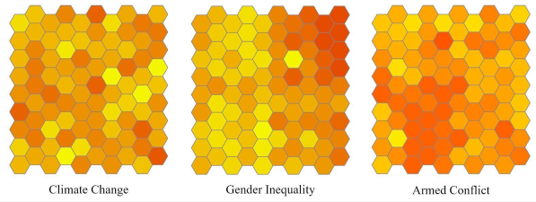
Stacking these overlays atop one another would result in a map that indicated the areas of greatest risk of women and girls suffering the compounding effects of armed conflict and climate change on their physical, social, economic, and political wellbeing, as shown below in the regions of darkest orange:

The criteria
For analytical simplicity and accuracy, the GIAC3 model uses only four or five criteria per factor overlay. The suite of criteria used for the respective overlays need to be flexible so that the criteria can be adapted to the most salient human security characteristics of an operational area. The criteria must also be holistic, and care must be taken to avoid the use of too-similar criteria for different overlays so that the model does not double-count certain impacts and thereby skew the results in the final map product.
For example, we propose a notional climate change overlay that has four criteria. The first is the percentage of arable land in a region, the second is regional expenditures for storm-related infrastructure damage, the third is prolonged exposure to high temperatures and humidity, and the fourth is climate-related disease incidence measured by deaths of children five years and younger attributed to diarrhea. The IPCC has included decreases in arability, damage to infrastructure through extreme weather events, heat exposure, and childhood mortality due to diarrhea as climate change risks in its reports, suggesting consensus regarding these factors’ usefulness in climate change impact assessments.
We have not had an opportunity to trial the model, and we recognize that we would need to work with experts in GIS modeling, gender, and climate change to construct a prototype with the most relevant metrics that would be suitable for field testing in a specific operational area. We would welcome the opportunity to collaborate with military organizations that might be interested in assessing its feasibility. Based on work done on mapping climate change vulnerability in Ethiopia, however, we believe that both our approach and the notional metrics we have tentatively selected are plausible.
The project’s authors first quantified vulnerability as equaling adaptive capacity (sensitivity + exposure). The metrics for each of these terms in the equation were very holistic from a human security perspective. The adaptive capacity component had three metrics: poverty ratio, literacy ratio, and the percentage of the entire area that was agricultural cropped land. The sensitivity component had four metrics, including the percentages of the population that were female and that were rural. The exposure component had three metrics: the change in maximum temperature, the change in minimum temperature, and change in precipitation. The resulting degrees of vulnerability were then mapped with color coding using a GIS system.
The Ethiopian climate change vulnerability model is analogous to our GIAC3 model in important ways. First, although the degree of vulnerability was quantified and then mapped, and in our model the degree of risk results from the stacking of color values in the mapping, both models provide a single risk assessment value. Second, the components of adaptive capacity, sensitivity, and exposure function in effect much the same as our overlays of gender inequality, armed conflict, and climate change. Third, each of the components is composed of a holistic suite of the metrics the project author found most useful to represent what was occurring specifically in the Ethiopian context, much as our model proposes to do.
The models do differ in important respects. The Ethiopian model uses accepted statistical methodology that provides mathematical rigor our model purposefully foregoes. On the other hand, even though the Ethiopian model uses holistic criteria (including gender) that cover the range of human security aspects of the area of study to assess climate change vulnerability, it does not explore the potential compounding effects of an additional factor, armed conflict, as a component of that risk as it relates to gender. On balance, we find that the Ethiopian model provides conceptual support for our approach. However, the question remains though—is our model likely to be useful in an operational setting?
The need for the model
We recognize that assessment of the relationships between gender inequality, armed conflict, and climate change faces very real challenges given the data gaps that exist in documenting and analyzing these factors world-wide, as shown for example by the relative paucity of data on gender inequality in crisis settings. At this point in time, however, we have not in our research been able to find examples of military units generating staff products similar to those the GIAC3 model could create to track the potential compounding effects of armed conflict and climate change upon at-risk women and girls. Without some practical and easily understood staff tool that seeks to measure this threat to human security, there is a risk that it might be overlooked even though it might be significant in achieving mission goals that are either explicitly or by implication based on fostering stability in host nations.
In this context then, even a map product that is more of a mosaic than a snapshot could have operational value. The mission resources that would be available to allocate to lines of effort that addressed these potential compounding effects are not likely to be plentiful to begin with. These resources could include securing time for instruction and practice on pre-deployment training schedules, and seeking units such as the Agriculture Development Teams or the gendered civil engagement units used by NATO-allied forces in Afghanistan. To gain the most value from whatever operational resources could be used, military headquarters would therefore need to focus their efforts where the need was likely greatest. Although it might present a mosaic with ill-fitting tesserae and some blank spots, the picture presented by the GIAC3 model could be good enough to identify where those areas were with a reasonable degree of accuracy.
The UN Security Council is making increasing progress on the integration of climate risks into its debates and even into some of its resolutions. From the perspective of human security, this work complements its recognition of the gender-differentiated impacts of armed conflict set out in the line of resolutions that have followed UN Security Council Resolution 1325 on Women, Peace and Security. In this sense, the intersection of gender inequality, armed conflict, and climate change is directly related to UNSCR 1325’s directive to increase protection for at-risk women and girls by fully using international human rights law and international humanitarian law.
To accomplish this, military missions require easier ways to more accurately assess where women and girls might be at greater risk of suffering the compounding impacts of armed conflict and climate change. In the hectic pace of the operational planning process, the risks posed to human security by these factors might be ignored if they are seen as too difficult to analyze or too vague to act upon with the resources available. If it were found to be feasible, our proposed model could build upon more typical gender analyses to provide a more accessible tool for military headquarters to make better reasoned decisions in sorting out how to support their human security lines of effort most effectively.
See also
- Ariana Lopes Morey, What does ‘back to basics’ mean for gender and the fundamental principles?, September 1, 2022
- Véronique Christory, Catching up with the curve’: the participation of women in disarmament diplomacy, August 25, 2022
- Jody M. Prescott, Why militaries need a theory of gender’s operational relevance, July 7, 2022
- Helen Durham, Cordula Droege, Lindsey Cameron & Vanessa Murphy, Gendered impacts of armed conflict and implications for the application of IHL, June 30, 2022

interesting and good tool. But just a tool. This article shows a lack of understanding of the military comprehensive planning process. PMESII mentionned in the article is just the beginning of the process and at each stage of the process you have some intermediate conclusion and interaction between all the domains analyzed. It takes into account gender, clinate change, water scarcity or vulnerable population. Fighting against silo is not done first and foremost with tools, it is a management and leadership guidance, that support building a collaborative and cohesive team with the willing to conduct an holistic analysis, to share information and to allow management to build a coherent strategy with objectives known and shared by all in order to conduct successfully the mission or the mandate.
Women always bear the brand in any conflict and hence all efforts are to be geared towards addressing issues likely to lead to conflict by all means. Also as women suffer so are poor innocent children who have no clue of the causes of conflict