


Our understanding of how severely armed conflicts have impacted natural resources, eco-systems, biodiversity and long-term implications on climate has massively improved over the last decade. Without a doubt, cataclysmic events such as the 1991 Gulf War oil fires contributed to raising awareness on the conflict-environment nexus, and the images of burning wells are engraved into our collective mind. But another more recent, under-examined yet major contributor to this growing cognizance is the digital revolution, which has provided us with a wealth of data and information from conflict-affected countries quickly made available through the internet. With just a few clicks, anyone with a computer or smartphone and a Wi-Fi connection can follow, often in near-real time, events shared through social media in warzones or satellite imagery showing what is unfolding on the ground.
These developments have significantly deepened our understanding of how military activities, both historically and in current conflicts, contribute to environmental damage and can impact the lives and livelihoods of civilians. Geospatial analysis through earth observation (EO) is now widely used to document international humanitarian law (IHL) violations, improve humanitarian response and inform post-conflict assessments.
These new insights on conflict-environment dynamics have driven humanitarian, military and political responses. The latter are essential for the protection of the environment in armed conflict: with knowledge and understanding also comes a responsibility to prevent, mitigate and minimize environmental damage, in line with existing international obligations. Of particular relevance, under international humanitarian law, militaries must take into account incidental environmental damage that is reasonably foreseeable based on an assessment of information from all sources available to them at the relevant time (ICRC Guidelines on the Protection of the Environment, Rule 7; Customary IHL Rule 43). Excessive harm is prohibited, and all feasible precautions must be taken to reduce incidental damage (Guidelines Rule 8, Customary IHL Rule 44).
How do we ensure that the data-driven strides forward in understanding conflict-driven environmental damage translate into proper military training and decision-making, humanitarian response and reconstruction efforts? How can this influence behaviour change and improve accountability for military actions and targeting decisions?
On satellites, sentinels and social media
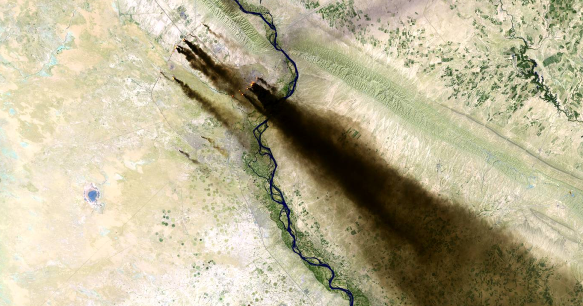
With thousands of satellites orbiting our planet, imagery from war zones is made publicly available through radar, sensor and optical data. Various types of low-, medium- and high-resolution imagery are captured on a daily or weekly basis, showing direct and indirect impacts, and providing the possibility to assess long-term trends in our environment and climate through spatio-temporal analysis. Through these data sets we can detect changes on the earth’s surface, temperature, precipitation, vegetation, sea water levels and forestry, which can be linked with conflict-events, including the actions of military operations, and climate change.
The international community was given an enormous boost when EO data became more easily accessible through user-friendly graphical interfaces such as Sentinel-Hub’s EO-Browser, offering free access to the National Aeronautics and Space Administration’s (NASA) optical imagery, the European Space Agency Sentinel’s constellation satellites, and high-resolution imagery from commercial providers such as MAXAR, Airbus and Planet Labs. Both NASA and the EU have sensors and platforms that detect fires in near-real time, including fire danger forecast options and rapid burned land analysis.
Some remote sensing data, e.g. heat detection, is directly uploaded online, making tracking fires relatively easy, while other optical imagery is made available with 12 hours. Larger data-sets became easier and faster to use for analysis by cloud-based services such as Google Earth Engine or other open-data cubes, or the FAO-supported Earthmap tool and UNEP’s World Environmental Situation Room, made available for quick historical environmental and climate analysis, e.g. water shortages, droughts and land degradation.
These and similar environmental security initiatives support trend monitoring and developing early-intervention mechanisms through the inclusion of specific medical or environmental expertise that deals with toxic remnants of war in humanitarian response. If this wealth of environmental impact data is available at the fingertips of humanitarian actors, it is equally available to militaries planning military operations. The scope and severity of environmental damage resulting from attacks is more foreseeable than ever before.
Worldwide growth in access to the internet and smartphones has led to a massive increase of information-sharing. Videos and images from warzones, when geo-located and verified, have been of tremendous help in identifying alleged violations of IHL, as well as in investigative journalism and monitoring of conflicts. PAX started to explore these new opportunities in 2015 through collecting data on conflict pollution in Syria. By combining conflict-event data with the Flash Environmental Assessment Tool (FEAT), developed for risk-assessment in natural hazard-induced disasters, we could provide insights into the civilian exposure risks from toxic chemicals. Combined innovative open-source investigative (OSINT) work developed by the Bellingcat collective verified data from conflicts and was combined with risk models to identify potential environmental hotspots. Soon, UN organizations started using this to assess environmental hazards during the battle of Mosul in Iraq, followed by humanitarian organizations exploring environmental risks from shelling of industrial sites in Donbas, eastern Ukraine, demonstrating the utility of these environmental risk assessments.
Growing application of data collection and analysis further provided insight on how conflict is affecting food and water security. The heavy shelling of agricultural areas during the harvest season in Syria resulted in massive fires destroying thousands of hectares of harvestable land, which were captured with EO and OSINT both in Syria and Iraq. Targeting of water infrastructure in Yemen and Syria, and the wider issues around water security linked with conflicts were also visualized through open-data analysis. These initiatives also supported academic analysis and follow-up research on damage to environmental infrastructure that influenced legal and policy debates on military conduct, for example on environmental harm from the use of explosive weapons in populated areas, the protection of civilians and relation with environmental damage as raised by the UN Secretary General in his reports and UN Security Council discussions, and the linkages between human rights and the environment in times of armed conflict.
Both data collection and risk modelling have paved the way for a more granular understanding of the environmental damage in armed conflict. These can be divided under direct and indirect impacts, including with each category a non-exhaustive list of consequences for people and ecosystems, as outlined in the overview below.
 From active conflicts in Syria and Yemen to environmental legacies from wars such as Vietnam or struggles with environmental peacebuilding efforts in Colombia, their impacts can be documented and taken into account for military planning, humanitarian response and post-conflict reconstruction efforts. The ICRC Guidelines, for example, comment that the scope of the obligation to take into account the indirect effects of an attack on the environment will be ‘informed by past practices and empirical data’ (para 118) – there is certainly a rich reservoir of past practice to inform contemporary military planning. The wealth of data is showing the direct public health risks to civilians, the natural resources they depend on, as well as biodiversity and conservation.
Gaps will remain in remote sensing data, either through limitations of satellite imagery (e.g. cloud-cover), or environmental impacts not visible from space. Verification through ground-truthing as well as collaboration with local sources remains key for attribution, contextualization of information and inclusiveness of the data assessment process. However, we already have more data to act on than ever before, which should spur evaluation of existing practices and policy and can already drive major improvements in response and reconstruction work on conflict-linked environmental damage.
Growing momentum on environment, peace and security
The growing body of evidence on the environmental consequences of armed conflicts is triggering profound changes both on the ground and in multilateral forums. For example, humanitarian organizations have begun implementing stronger environmental components into their work streams through information-sharing and environmental awareness in project interventions. Initiatives such as the Climate and Environment Charter for Humanitarian Organizations or the DRC Framework on Climate Change and Environment are positive examples of this push forward, while humanitarian demining organizations are also including environmental mainstreaming in their project planning.
A surge in academic research and humanitarian evidence demonstrating the acute and long-term environmental implications from conflicts has positively shifted the political discussion throughout the UN system on the linkages between environment, climate, peace and security in recent years. With legal discussions driven by the International Law Commission on the protection of the environment in armed conflicts, and the UN Environment Assembly’s resolutions 2.15 on PERAC and 3.1 on conflict pollution, compounded by evidence from ongoing conflicts, helped strengthen civil society efforts to address the conflict-environment nexus. Further discussion in UN Security Council Arria-formula meetings and open debates on environment, climate, and conflict, as well as in country-specific briefings, such as those on Yemen, contributed to attention in New York, furthered by high-level UN General Assembly discussions on the humanitarian effects of environmental degradation, and the UN Secretary General’s reports on protection of civilians.
Environmental horizons
Through better data collection, analysis and awareness-raising by civil society and journalists, the application of an environmental lens in conflicts has helped magnify the underlying humanitarian, peace and security implications. The challenge ahead is how to translate this into better protection mechanisms for the future of people and the planet.
First, our enhanced knowledge of environmental consequences of military operations should be leveraged to support more behaviour-change, improved compliance with IHL obligations, and accountability and transparency in military conduct. Through the ICRC’s updated Guidelines on the Protection of the Natural Environment in Armed Conflict, training of armed forces and influencing of military doctrine, policy and practice can prevent or mitigate such impacts. Increasingly armed forces are reassessing environmental considerations, including linkages with protection of civilians, as they become increasingly aware of both direct consequences but also the long-term climate security risks exacerbating such consequences. They can also have a role in sharing data on targets and environmental assessment with relevant actors in post-conflict settings to support clean-up and remediation efforts.
Second, with rapid assessment and predictive analysis on acute and long-term environmental health risks, improved humanitarian response can save lives and livelihoods. Information-sharing between clusters and having a set of specific conflict-linked environmental indicators can build an efficient mechanism that collects and disseminates data on pollution, environmental degradation, biodiversity, and food-and water security. These insights should also lead to efficient UN-wide response options to specific environmental-linked health and livelihood impacts of conflict and ensure organizations have expertise and capacity to prevent or minimize acute environmental health risks, or contribute to rapid clean-up and remediation efforts in post-conflict settings, for example through nature-based solutions.
Finally, we now must strike while the iron is hot and mainstream environment, peace and security both within and outside the UN system. Within the UN, significant improvement can be achieved to improve cross-sector collaboration that brings together expertise to ensure proper knowledge and expertise-sharing to address environmental issues through the cycle of conflicts under a larger environmental umbrella. Outside the UN, a wider coalition of civil society groups, affected communities and experts is needed to spur action for nature in relation to armed conflict and climate security. States need to take steps to include environmental concerns in their own bilateral development and aid packages. This entails also working with and supporting local civil society and peacebuilders with capacity and consultation for sustainability of green ‘building back better’ programs. Through these combined efforts, utilizing digital innovation with inclusion of environmental dimensions in law and policy compliance and international policy responses, there is now a unique opportunity to strengthen the protection of our planet, people and peace.
See also
- Ambassador Marja Lehto, Overcoming the disconnect: environmental protection and armed conflicts, May 27, 2021
- Vanessa Murphy & Helen Obregon Gieseken, Fighting without a Planet B: how IHL protects the natural environment in armed conflict, May 25, 2021
- Doug Weir, Conflict and Environment Observatory, Six ways to mainstream the environment in peace and security, May 26, 2021

This is a very relevant article linking environment, peace and security. As an environmentalist, conservationist and both environment and human ecologist — I just think an environment agenda in armed conflicts is under-addressed when compared to other programs like mining, construction, energy, forestry and the likes.
But I am very happy to see that ICRC is taking environmental issues so seriously and while it is so obvious that ‘armed conflicts’ drive environment into chaotic situations, the extent and severity ‘armed conflicts’ render to the environment is very serious. Whether negative environmental consequences are direct or indirect, they both result into everlasting and far-reaching ecological, social and economical effects.
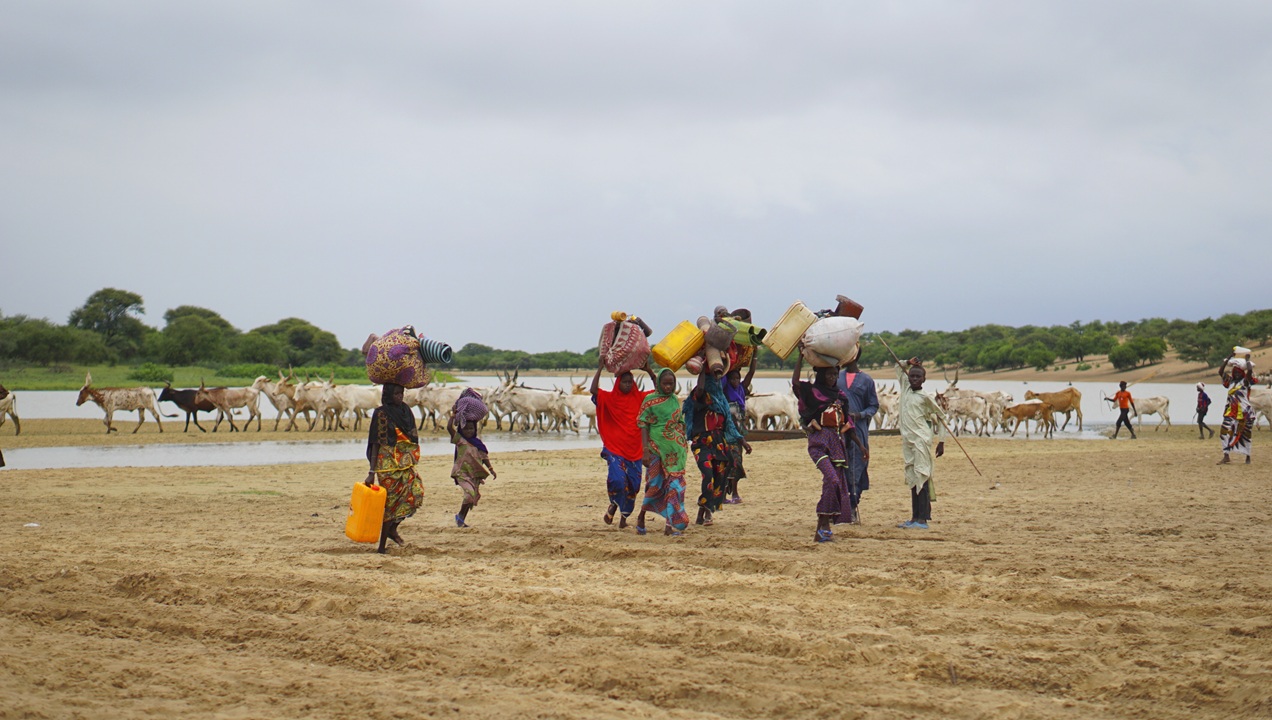
Let’s take a look into ‘armed conflicts’ consequences in the DRC. Internally Displaced People — due to loss of their sources of Livelihoods, encroached natural forests. This resulted into IDPs to chop down trees in order to get materials for house building, firewood for energy, and other uses. Natural forests degradation, deforestation and extraction of other resources have also affected habitats for endangered species including chimpanzee and mountain gorillas and many more species.
Further, IDPs can embark on unsustainable farming here and there and this could have serious damage to the natural environment. By unsustainable farming along riverbanks can cause soil erosion, can set up bushfires and in the end can exhaust soil fertility beyond recovery.
So, collaboration between different actors in integrating environment agenda in ‘armed conflict settings’ is crucially important. But, with unclear data and information on environmental issues is difficult in communicating Environmental Objectives across different actors operating in different parts of the world.
Environmental Data Harmonization, Clearly Defined Data, Central Data Center, and Environmental Experts are all important tools in dealing with environmental issues in ‘armed conflicts settings’ and it is very important that Environmental Experts — be on frontline in shaping the Environmental Agenda in ‘armed conflicts settings.’
Dear Godfrey,
Thank you for your insights and sharing of of expertise on the DRC. We’re seeing similar unsustainable coping strategies also playing out in South Sudan, Syria and part of Iraq. With rapid data collection, ideally this should lead to a rapid intervention that would provide more sustainable energy resources to displaced populations, and result in inclusion of reforestation and environmental restoration efforts in post-conflict program work to limit the impacts.
We hope these new tools and methods can contribute to that and thanks again for contributing to this debate with your experiences.
Wim